Agriculture is dictated by weather patterns. It might be a very simple fact, but nonetheless essential in understanding what, when and how much produce reaches your local grocery store.
Weather phenomena such as droughts or hurricanes can severely impact what any farm around the world can produce. In Costa Rica, where our farms are based, recent storms have caused workers to press the pause button on much of our vital agricultural practices. These storms, many have claimed, are due to this year’s El Niño event.
In fact, forecasters from the National Oceanic and Atmospheric Administration (NOAA) announced this past month that this year’s El Niño could become among the strongest on record and will likely last into early spring 2016.

So, what exactly is El Niño and why have you heard it before? Here are 10 quick facts you should know!
- “El Niño” is the name of an occurring, temporary change in the climate of the Pacific Ocean.
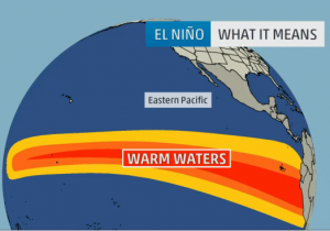
When someone says there’s an “El Niño” event this year, they’re talking about unusually warm ocean temperatures recorded in the Pacific region around the equator.
- During a non-El Niño year, warm water storms are usually created in the Pacific Ocean and move westward.
To understand how El Niño changes things, first it’s important to understand what’s considered “normal”. In the Pacific Ocean, the water closest to the equator is warmed by the sun. Wind in the region will blow from east (the Americas) to west (Asia and Australia). These gusts of wind—called prevailing winds—take the newly formed warm surface water temperatures with them, making the water near the Americas, as a result, usually cooler by comparison.
- El Niño is a disruption of this “normal” system. During El Niño, trade winds tend to relax and fail to send the rest of the warm air westward.
As a result, warm water builds and builds in the east “until at some point, the system says, ‘Whoa, too much! I’m going to get rid of it!’” Kevin Trenberth, a climate scientist at the U.S. National Center for Atmospheric Research in Colorado, explains. This is when an El Niño event has the potential to kick in.
- The El Niño change is then marked by higher than average ocean surface temperatures in the Pacific Ocean at the Equator, for at least three months.
All of this commotion happening between west and east trade winds results in warmer than normal surface temperatures. This shift in warmth increases the potential of heavy rains, flooding and disrupted fish habitats near the Americas and creates drought conditions in the western Pacific.
- El Niño’s timing usually follows a pattern each decade.
It usually happens every three to seven years, starting slowly in the Northern Hemisphere’s summer, peaking in its winter and dying off quickly in the New Year.
- El Niño translates to “The Christ Child” in Spanish.
Peruvian fishermen are credited with naming the event after they noticed that every few years, around Christmas, virtually no fish could be found in the unusually warm waters.
- Forecasters can quantitatively state how “strong” an El Niño event can be.
Officially, an event is deemed a weak El Niño event if the sea surface temperatures increases by more than 0.5 degrees Celsius (0.9 degrees Fahrenheit) above normal. At 1.0 degree Celsius above normal, an event is moderate, while anything above 1.0 degrees is considered strong. Currently, this El Niño event is reported at 1.5 degrees Celsius above normal.
- Strong El Niño events can have a major impact on global weather phenomena.
More frequent and intense storms and heavy rain and snowfall in certain parts of the United States will usually occur as a result of a strong El Niño winter. An increase in tropical cyclones in the Pacific and decreased hurricanes in the Atlantic can result as well.
- El Niño developed in March of this year.
Many local Costa Rican operations, like Chestnut Hill Farms, have felt the impact of El Niño. As the event continues to strengthen, the region continues to see major rainfall.
- NOAA provides monthly update for El Niño activity.
Can’t get enough El Niño now that you know what it actually is? The National Oceanic and Atmospheric Administration (NOAA) keeps the world abreast of its latest forecasts. Check them out here.
Dr. Lloyd
*Many facts were taken from both the NOAA’s website and a wonderful explanation by Maria Gallucci of the International Business Times. Read her full article here.


